I live! And not only do I live, but I've had an intensely busy and extremely productive August and September, with a combination of conferences, personal travel, research, and many many hours of work (and hours of sleep lost) on an outreach project called "Faults of California." I'll post more extensively about that project once it's at the point where I can actually show it to you, but for those of you who follow me on Twitter, this is related to all of the stuff I've been posting about "talking faults" and "comic books."
Anyway! Last week was the annual Southern California Earthquake Center meeting in Palm Springs. Last year's SCEC meeting was my very first scientific conference ever, and even though I went before I'd had any graduate level earth science classes, I still came out of it with tons of ideas for things I wanted to research. This year, now that I've been taking seminars and doing research all year, was even better. I had a much better overall understanding of posters and talks, but even more important, I was much better able to really converse with the people stopping by my poster or the people whose posters I visited, rather than merely explaining what I did, or merely listening to their own explanations. So, in addition to giving me yet another huge load of ideas I'd love to research/model, this year's SCEC meeting also served as a good marker for what a year of work can do. I'm certainly not thinking of myself as "that hack with a music degree" as much as I used to!
A hopefully-brief day-to-day rundown of the meeting:
Saturday, 12 September
Arrived in Palm Springs by 9:30 AM, for the beginning of a workshop on dynamic weakening mechanisms at 10 AM. The research presented in this workshop consisted primarily of laboratory experiments on various types of rock and fault gouge, most of which used a rotary shear device, though with different sets of stresses and different effects being observed. The particular focus seemed to be on assorted flash heating effects, and also the possibility of gels being created from fluid and silica on faults. There seemed to be a little frictional heating between the differing presenters, who sometimes disagreed on each other's experimental setups or interpretation of results, but even with the debate, it was enlightening to see some of the experimental work that goes into the friction laws and fault behavior equations that are coded into the modeling software I use on a regular basis. Toward the end of the day, I slipped out to hear a friend's talk in a workshop on transient detection; his talk was quite clear and well-delivered, though the other two before it were far too caught up in a type of math I haven't yet learned to make any sense to me.
Sunday, 13 September
The second annual SCEC student field trip was to San Gorgonio Pass. This area is particularly intriguing to me because it's a total mess of fault geometry, with curves, bends, branches, and stepovers, with transitions from strike-slip to thrust and back again. This is the kind of crazy complexity I'd love to model at some point, and getting to actually walk all over it and see contact points and evidence of the collision of the Mt. San Jacinto block with the San Bernardino Mountains brought the details of this unusual area far more into light than only reading about them would have. The field trip focused on features associated with these transitions in fault behavior: we looked at strike-slip features like shutter ridges in alluvial fans near Garnet Hill and an incredibly clear juxtaposition of schist and sediment in Whitewater Canyon (where I'd helped install a seismic array last October - guess my back was to this contact point the whole time then!), but only a few kilometers to the northwest, there were 12-meter thrust fault scarps. The last stop was the southern terminus of the clearly-mapped continuous San Andreas Fault. North of there, the Fault can be followed clear through to Point Arena, but the whole San Gorgonio knot to the south still hasn't been unraveled. Seeing these features and talking with the trip leaders gave me a ton of ideas for specific questions to ask and points to finetune in future modeling, and fortunately, the trip leaders said I could continue to pick their brains on this matter as I get into modeling specific faults. After the trip, I hung my poster, and also helped set up the "Faults of California" display in the hallway. It was very odd to have my artwork taking up a whole hallway, though I didn't stand next to it. I put a sign next to it directing people to find me at my research poster - a way to get people to talk to me about both!
Monday, 14 September
The meeting proper started on the 14th. Unlike last year, which separated out organizational discussions for different branches of SCEC, this year had a scientific talk followed by an organization-wide planning session at least tangentially related to the topic of the talk. Monday's talks concerned tremor on the San Andreas at Parkfield (and how it connects to repeating microearthquakes), and how earthquake scientists and engineers can better communicate with each other about their work and needs. I don't remember as much about the objectives discussions on this day as on Tuesday; I admittedly paid a little less attention since they were related to the parts of SCEC less related to my own work, and thus were issues about which I had no particular opinion. I hope - and suspect - that I'll be able to get more and more out of these more distant topics with each consecutive SCEC meeting. The thing I got the most out of on Monday was the poster session; my poster was about the effect of fault stepovers on ground motion, and it was therefore filed with the ground motion group as opposed to the rupture mechanics group. I ended up having a huge amount of traffic and discussion around my poster for both the afternoon and evening session, to the point where I didn't even get a chance to look at any of the other posters. A good problem to have, particularly considering how many ideas for things to look at within the scope of this project I got out of it!
Tuesday, 15 September
Tuesday's plenary talks were another take on dynamic weakening mechanisms (which included video of one rock sample exploding on the shear apparatus), whether or not the Gutenberg-Richter relation actually applies to faults, and a look at the southern California crust with seismic tomography. Of these, the Gutenberg-Richter one prompted the most discussion, in the form of a very heated debate that cut into planning time and continued to crop up in discussion for the rest of the whole conference. It was not enough to entirely deflect the discussion of what modelers and field geologists can do for each other, however. This planning session included the request for more detailed maps of fault geometry (yay!), with the possibility of a community fault mesh that anyone could adapt to their models without having to remesh anything. I certainly hope that these things come to pass, since limited understanding of geometry and the problems of meshing the complexity we do know about put some definite limits on modeling. The rupture dynamics posters were up in the Tuesday session, but once again, I was kept from getting to see very many of them because I was held up at my own work. I didn't plan to hover near the "Faults of California" printout in the hallway, but people dropped by to ask things, and before I knew it, the afternoon session was over. In the evening, I got to walk around the other posters for a few minutes, but then I had a meeting with the guy in charge of education at SCEC to discuss specific things to be done with "Faults of California." It was a very productive talk, even though I missed so many posters. Good thing there are abstracts in the conference program booklet...
Wednesday, 16 September
There was only one plenary talk on Wednesday, and it had to do with earthquake forecasting (but not earthquake prediction). It was an interesting talk, but the planning session afterward was even more interesting to me. I forget the prompt exactly, but it got onto the matter of fault systems and geometry, and there seems to be general agreement that the next phase of SCEC should include an objective for major focus on interactions between faults. There was specific mention of the San Andreas/Garlock intersection, which is of particular interest to me. I'll be pretty far into my PhD work by the time SCEC4 actually starts (2012), but if that work is in an area that's one of the main objectives, that will hopefully mean good things in terms of postdocs or jobs in the future.
I guess I failed at being brief (I guess I had to unload a lot of words after sitting there silently for two months!), but I reiterate that it was an awesome conference overall, and I have a lot more to think about and do over this year and the next few thanks to it.
(And I will hopefully be able to post more about "Faults of California" soon. In the meantime, now that the bulk of work on it is done, I should be posting here more in general. I hope.)
Showing posts with label field trips. Show all posts
Showing posts with label field trips. Show all posts
Wednesday, September 23, 2009

Sunday, May 17, 2009
A day of kinematic GPS
I really don't mean to be neglecting my blog (or neglecting commenting on your blogs) as much as I have been lately. It's mostly that, after the classes and the rehearsals and the homework and the grading, I put aside the papers and think only of sleep, rather than of spending more time at a screen writing things. I'm accumulating a rather lengthy To-Blog list, which, following Maria's lead> I think I'll have to make a summer break resolution (since New Year's is way too far off) to actually write up.
Anyway, though much of my time this quarter has been spent at a desk, the seminar I'm taking on tectonic geomorphology and quaternary field methods has served well to get me out and about. Many of our "trips" have been into the hills behind campus, mostly for funding reasons, but we have had a few larger outings. The most intensive one so far was when we went to Grass Valley in the San Bernardino Mountains to make a digital elevation map using kinematic GPS. (There was also a USGS/Caltech team out there using LiDAR to image some precariously balanced rocks, but we did not get to actively participate in this part of the work; we were mere observers.)
Grass Valley is located in the San Bernardino Mountains, not far from Lake Arrowhead. It falls into the region of highest possible threat of major earthquake ground motion in the state, due to its proximity to several major faults. The San Andreas Fault is 11 kilometers away, with several well-constrained paleoseismic sites within 20 km. The San Jacinto Fault is only a kilometer or two further away than the San Andreas; the north frontal thrust of the San Bernardino Mountains is about the same distance away to the north. The Cleghorn Fault runs directly through Grass Valley, though its activity isn't as well constrained; there's no current microseismicity, and no evidence of Holocene rupture.
The precariously balanced rock team was clearly there to try and constrain whether or not the worst case scenario of shaking according to the state hazard report had actually ever happened since those rocks became precarious to begin with. The focus of the class exercise, however, was more on a catchment containing a small system of drainages in the process of being captured by the Mojave River. Our goal was to use kinematic GPS to get a good picture of the area, which could then be used to better situate the precariously balanced rocks in the middle of the site.
Kinematic GPS is a method of relative measurement. Actual latitude/longitude figures don't come into play. All measurements are taken relative to a base station that gets set up somewhere central in the site, for the express purpose of kinematic GPS measurement. People then carry portable GPS antennae, either attached to a backpack or on a long pole, all over the area surrounding the base station. The goal is to go back and forth over all of the bumps and dips in topography - even though that does, of course, make for harder hiking at times - to make sure they show up in the DEM. The data has to be corrected for height of the person carrying the antenna (I was not, shockingly, the shortest one!) and for roughness of gait, but the corrections that need to be made can be gauged by having all of the antenna-carryers walk the same path before going their separate ways.
We spent a full afternoon tromping around the catchment, and the four of us managed to cross paths only a couple of times, hopefully implying that we didn't all cover the same ground. In my run-in with one of the professors, I was detailed to walk around the far edge of the site that hadn't yet been covered. I did so, but then I proceeded to overshoot the other edge of the site and get quite confused. I continued to walk through all of the (mostly-dry) drainages I could find for a while, but I started to get worried when I wasn't catching sight of the base station or the precariously balanced rocks. I definitely realized the irony of not having a clue where I was, despite having a GPS antenna strapped to my back, but dark humor wasn't going to get me out of the situation on its own. I did manage to work my way back to the road, then proceeded to go the wrong way on it for about half a mile before I noticed that I was wrong. It turns out I'd found the road only about 200 yards shy of the turnoff that lead straight to the base station. Ah well!
I haven't seen our DEM yet, though I'm told we covered a lot of ground, and I'm told that there was one antenna that went quite a bit further away than all the others did. One of the people in the class is doing all the processing as his final project for said class, so I may ask him if I can show off the results of our day in the field.
Anyway, though much of my time this quarter has been spent at a desk, the seminar I'm taking on tectonic geomorphology and quaternary field methods has served well to get me out and about. Many of our "trips" have been into the hills behind campus, mostly for funding reasons, but we have had a few larger outings. The most intensive one so far was when we went to Grass Valley in the San Bernardino Mountains to make a digital elevation map using kinematic GPS. (There was also a USGS/Caltech team out there using LiDAR to image some precariously balanced rocks, but we did not get to actively participate in this part of the work; we were mere observers.)
Grass Valley is located in the San Bernardino Mountains, not far from Lake Arrowhead. It falls into the region of highest possible threat of major earthquake ground motion in the state, due to its proximity to several major faults. The San Andreas Fault is 11 kilometers away, with several well-constrained paleoseismic sites within 20 km. The San Jacinto Fault is only a kilometer or two further away than the San Andreas; the north frontal thrust of the San Bernardino Mountains is about the same distance away to the north. The Cleghorn Fault runs directly through Grass Valley, though its activity isn't as well constrained; there's no current microseismicity, and no evidence of Holocene rupture.
The precariously balanced rock team was clearly there to try and constrain whether or not the worst case scenario of shaking according to the state hazard report had actually ever happened since those rocks became precarious to begin with. The focus of the class exercise, however, was more on a catchment containing a small system of drainages in the process of being captured by the Mojave River. Our goal was to use kinematic GPS to get a good picture of the area, which could then be used to better situate the precariously balanced rocks in the middle of the site.
Kinematic GPS is a method of relative measurement. Actual latitude/longitude figures don't come into play. All measurements are taken relative to a base station that gets set up somewhere central in the site, for the express purpose of kinematic GPS measurement. People then carry portable GPS antennae, either attached to a backpack or on a long pole, all over the area surrounding the base station. The goal is to go back and forth over all of the bumps and dips in topography - even though that does, of course, make for harder hiking at times - to make sure they show up in the DEM. The data has to be corrected for height of the person carrying the antenna (I was not, shockingly, the shortest one!) and for roughness of gait, but the corrections that need to be made can be gauged by having all of the antenna-carryers walk the same path before going their separate ways.
We spent a full afternoon tromping around the catchment, and the four of us managed to cross paths only a couple of times, hopefully implying that we didn't all cover the same ground. In my run-in with one of the professors, I was detailed to walk around the far edge of the site that hadn't yet been covered. I did so, but then I proceeded to overshoot the other edge of the site and get quite confused. I continued to walk through all of the (mostly-dry) drainages I could find for a while, but I started to get worried when I wasn't catching sight of the base station or the precariously balanced rocks. I definitely realized the irony of not having a clue where I was, despite having a GPS antenna strapped to my back, but dark humor wasn't going to get me out of the situation on its own. I did manage to work my way back to the road, then proceeded to go the wrong way on it for about half a mile before I noticed that I was wrong. It turns out I'd found the road only about 200 yards shy of the turnoff that lead straight to the base station. Ah well!
I haven't seen our DEM yet, though I'm told we covered a lot of ground, and I'm told that there was one antenna that went quite a bit further away than all the others did. One of the people in the class is doing all the processing as his final project for said class, so I may ask him if I can show off the results of our day in the field.
Wednesday, October 15, 2008
Rapid-Response Seismic Array Drill
I had my first experience in setting up an array of seismic stations this past Thursday! In conjunction with the Great Southern California ShakeOut - though not directly part of the drill - one of the professors in our department wanted to do a practice rapid response deployment on the San Andreas. She asked for volunteers among students and faculty alike to help with the deployment; I jumped at the chance, initially thinking it would just plain be a good experience. I realized a little later that, if there were to be a significant earthquake in the area, and if part of this professor's job is to go out and deploy stations, those of us who helped with the practice run might actually be enlisted to help out when the real deal happens. Exciting!
Our practice run took us to Whitewater, California, between Palm Springs and Cabazon. This little bitty town sits on top of the active Banning strand of the San Andreas, and part of the fault's trace is indicated by a distinct band of green trees set against the brown of Whitewater Canyon's plant life and rocks. The green part, however, was not the part where we put the stations. We had permission from the owner of a large chunk of the land in the canyon to pepper his property with equipment. (For a House-On-Fault guy, he seemed pretty with it. Not that choosing to live on the fault is the best move, but he knew its general direction relative to the house, had the house retrofitted, and was willing to let scientists do their thing!) We actually had a harder time finding the fault on this guy's land than we would have expected. All of the fault features were subtle, and within our group of about ten people, we had three different guesses, though all were within about 100m of each other. In the end, I think we got pretty darn close to sticking our "midpoint" station on the actual fault, since it was easiest to dig holes there, and the soil got chunkier and with larger rocks the further out from the midpoint we went.
We set up eleven stations: one supposedly on the fault itself, five to the north, and five to the south. The first four of each of those were spaced 50 meters apart, with the final station 100 meters away from the previous one. We did the installation in stages, visiting each station a few times throughout the day, rather than doing each step in one go and leaving the station be. The first step was digging holes - two per station, one for the strong motion sensor and one for the weak motion sensor. I personally dug five holes, and definitely felt it the next day. im in ur fault diggin holez
After the holes were finished, we set out the equipment. Each station included a strong motion sensor (with the brand name EpiSensor - gotta love how punnable seismology really is!), a weak motion sensor, a solar panel, a GPS transmitter, a control box for the solar panel, a control box for the entire setup, and a truck battery. The third pass over all of the stations was to actually hook all of the things up, turn them on, bury the sensors, and try and keep the boxes of equipment and solar panels out of view from the nearby road. This proved to be no small feat for the station furthest to the north, since the site was maybe 50m from said road. But we were resourceful and tricsky, and using various tumbleweed and dead creosote bush parts and various other partially burned dead plants, we constructed a row of bushes where there had only been tufts of grass before. It looked natural from the road, and we made sure to actually secure the wood in the dirt, and to weigh it down with rocks. Here's hoping it doesn't blow away!
 Marvel at our artificial bushes! There is a solar panel in this photo, really!
The last step was to make sure all the sensors were recording as they were supposed to. The weak motion ones could be set off with a good hard stomp, but we were having a hard time testing the strong motion ones. Stomping, even in conjunction, barely got a flicker. It required dropping of the largest liftable rocks on site to get a testable reading. "Can You Trip The Strong Motion Detector" definitely sounds like some sort of strange game show, does it not?
The deployment ended up taking most of the day - not exactly the most rapid response ever. Naturally, people who aren't doing this for the first time can get stations up much faster! I'd like to think our little UCR crew would be faster the next time, too. The stations will stay in place for about two months. Since that particular section of the fault has a lot of microseismicity, these stations ought to pick up some events, making them definitely useful for more than just an installation drill. And if the Big One does hit within those two months, well, we'll be a step ahead in the deployment, right? Riiiight?
Our practice run took us to Whitewater, California, between Palm Springs and Cabazon. This little bitty town sits on top of the active Banning strand of the San Andreas, and part of the fault's trace is indicated by a distinct band of green trees set against the brown of Whitewater Canyon's plant life and rocks. The green part, however, was not the part where we put the stations. We had permission from the owner of a large chunk of the land in the canyon to pepper his property with equipment. (For a House-On-Fault guy, he seemed pretty with it. Not that choosing to live on the fault is the best move, but he knew its general direction relative to the house, had the house retrofitted, and was willing to let scientists do their thing!) We actually had a harder time finding the fault on this guy's land than we would have expected. All of the fault features were subtle, and within our group of about ten people, we had three different guesses, though all were within about 100m of each other. In the end, I think we got pretty darn close to sticking our "midpoint" station on the actual fault, since it was easiest to dig holes there, and the soil got chunkier and with larger rocks the further out from the midpoint we went.
We set up eleven stations: one supposedly on the fault itself, five to the north, and five to the south. The first four of each of those were spaced 50 meters apart, with the final station 100 meters away from the previous one. We did the installation in stages, visiting each station a few times throughout the day, rather than doing each step in one go and leaving the station be. The first step was digging holes - two per station, one for the strong motion sensor and one for the weak motion sensor. I personally dug five holes, and definitely felt it the next day.
 im in ur fault diggin holez
After the holes were finished, we set out the equipment. Each station included a strong motion sensor (with the brand name EpiSensor - gotta love how punnable seismology really is!), a weak motion sensor, a solar panel, a GPS transmitter, a control box for the solar panel, a control box for the entire setup, and a truck battery. The third pass over all of the stations was to actually hook all of the things up, turn them on, bury the sensors, and try and keep the boxes of equipment and solar panels out of view from the nearby road. This proved to be no small feat for the station furthest to the north, since the site was maybe 50m from said road. But we were resourceful and tricsky, and using various tumbleweed and dead creosote bush parts and various other partially burned dead plants, we constructed a row of bushes where there had only been tufts of grass before. It looked natural from the road, and we made sure to actually secure the wood in the dirt, and to weigh it down with rocks. Here's hoping it doesn't blow away!
 Marvel at our artificial bushes! There is a solar panel in this photo, really!
The last step was to make sure all the sensors were recording as they were supposed to. The weak motion ones could be set off with a good hard stomp, but we were having a hard time testing the strong motion ones. Stomping, even in conjunction, barely got a flicker. It required dropping of the largest liftable rocks on site to get a testable reading. "Can You Trip The Strong Motion Detector" definitely sounds like some sort of strange game show, does it not?
The deployment ended up taking most of the day - not exactly the most rapid response ever. Naturally, people who aren't doing this for the first time can get stations up much faster! I'd like to think our little UCR crew would be faster the next time, too. The stations will stay in place for about two months. Since that particular section of the fault has a lot of microseismicity, these stations ought to pick up some events, making them definitely useful for more than just an installation drill. And if the Big One does hit within those two months, well, we'll be a step ahead in the deployment, right? Riiiight?
Friday, September 12, 2008
SCEC Day Two
It would appear that I have failed miserably at live-blogging the SCEC conference. That said, I will still post about each day at a time! Just, you know, offset by a few days. I'm studying strike-slip faults; I'm good at offset. Yeah...
Day Two of the conference included a field trip for students only. Our advisers and mentors all got to sit in the too-cold hotel and listen to organizational talk, while we got to go hang out in Anza-Borrego Desert State Park. Despite the 110-degree heat, we students clearly got the better end of the deal.
The purpose of the field trip was to look at features of the San Jacinto Fault, and the trip was led by a PhD student whose dissertation is on the particular part of the fault we visited. I got the impression that, given how the trip leader described what a scarp is and how it formed, and how streams get offset, that this trip was more geared toward people who had not seen fault features up close and personal before. That said, I am always glad for a chance to poke those features, particularly in places I haven't been before! The San Jacinto in Anza Borrego has many strands, some separated by a couple of kilometers, some only by a few feet. The latter manifested itself by chopping an alluvial fan into narrow shreds; the shred moved by the most active strand of fault is also marked by a four-foot scarp. There were also offset streams on all sorts of scales. The trip led us from one that was only deflected by three feet all the way to one that, rivaling the San Andreas' Wallace Creek on the Carrizo Plain, was pulled over a hundred feet to the right. That is quite a testament to the power of this young and active fault!
(I took a ton of pictures of these features, but all the good ones are in the form of panoramas, which I have not yet stuck together yet. I'll be posting them once they're done!)
We took about half an hour for lunch, then continued on to look at a mylonite zone high on a ridge. In order to get there, the tour bus had to go on a narrow and winding road that was clearly not designed with tour buses in mind. This made me nervous in and of itself, but I nearly started shaking when the bus turned toward the edge of the cliff. I realized, only when we did not start falling, that there was a turnaround here and we were actually trying to park. Parking was successful, but that still wasn't a shock that I needed. The mylonites in question were down the cliff from the bus, and only about half of us (myself included) actually climbed down to look. I was disappointed that they did not clang harmoniously beneath my feet (as Kim has observed with a different mylonite zone), but they made up for it by having very clearly defined shear/scrape marks, even on top of the elongated mineral grains. This is not something I'd seen up close before, and I thought it was very very cool.
On the ride back to Palm Springs, I was still so excited about the trip that I was sure I'd be awake and alert enough to catch the end of the Southern San Andreas Fault Evaluation (SoSAFE) workshop, but as soon as I got back into the air conditioned hotel, the exhaustion of spending several hours outside in the desert in summer hit me, and I decided a nap would be the obvious use of my time (or rather, my body decided this for itself). The most useful thing I did for the rest of the evening was help a friend of mine put up her poster (there were two sessions, hers was in the first, mine was in the second). I looked at a few posters as well, but my attention span was shot from tiredness, so I mostly took mental notes of which I wanted to come back to the next day and look at in more detail. I was not too braindead to appreciate the plate tectonics puzzle game for little kids, though. I think I want one, nevermind that I'm 24!
Day Two of the conference included a field trip for students only. Our advisers and mentors all got to sit in the too-cold hotel and listen to organizational talk, while we got to go hang out in Anza-Borrego Desert State Park. Despite the 110-degree heat, we students clearly got the better end of the deal.
The purpose of the field trip was to look at features of the San Jacinto Fault, and the trip was led by a PhD student whose dissertation is on the particular part of the fault we visited. I got the impression that, given how the trip leader described what a scarp is and how it formed, and how streams get offset, that this trip was more geared toward people who had not seen fault features up close and personal before. That said, I am always glad for a chance to poke those features, particularly in places I haven't been before! The San Jacinto in Anza Borrego has many strands, some separated by a couple of kilometers, some only by a few feet. The latter manifested itself by chopping an alluvial fan into narrow shreds; the shred moved by the most active strand of fault is also marked by a four-foot scarp. There were also offset streams on all sorts of scales. The trip led us from one that was only deflected by three feet all the way to one that, rivaling the San Andreas' Wallace Creek on the Carrizo Plain, was pulled over a hundred feet to the right. That is quite a testament to the power of this young and active fault!
(I took a ton of pictures of these features, but all the good ones are in the form of panoramas, which I have not yet stuck together yet. I'll be posting them once they're done!)
We took about half an hour for lunch, then continued on to look at a mylonite zone high on a ridge. In order to get there, the tour bus had to go on a narrow and winding road that was clearly not designed with tour buses in mind. This made me nervous in and of itself, but I nearly started shaking when the bus turned toward the edge of the cliff. I realized, only when we did not start falling, that there was a turnaround here and we were actually trying to park. Parking was successful, but that still wasn't a shock that I needed. The mylonites in question were down the cliff from the bus, and only about half of us (myself included) actually climbed down to look. I was disappointed that they did not clang harmoniously beneath my feet (as Kim has observed with a different mylonite zone), but they made up for it by having very clearly defined shear/scrape marks, even on top of the elongated mineral grains. This is not something I'd seen up close before, and I thought it was very very cool.
On the ride back to Palm Springs, I was still so excited about the trip that I was sure I'd be awake and alert enough to catch the end of the Southern San Andreas Fault Evaluation (SoSAFE) workshop, but as soon as I got back into the air conditioned hotel, the exhaustion of spending several hours outside in the desert in summer hit me, and I decided a nap would be the obvious use of my time (or rather, my body decided this for itself). The most useful thing I did for the rest of the evening was help a friend of mine put up her poster (there were two sessions, hers was in the first, mine was in the second). I looked at a few posters as well, but my attention span was shot from tiredness, so I mostly took mental notes of which I wanted to come back to the next day and look at in more detail. I was not too braindead to appreciate the plate tectonics puzzle game for little kids, though. I think I want one, nevermind that I'm 24!
Monday, August 18, 2008
Pull-apart basins of the Inland Empire
Last Wednesday, despite the ludicrous August-in-SoCal temperatures, those of us who are hanging around the UCR geology building this summer had the opportunity to go on a field trip to look at pull-apart basins on the San Andreas and San Jacinto Faults. The trip was led by one of the senior faculty members here, who worked at USGS for a long time (and whose name is on quite a few USGS maps of the area) before coming to teach here; I'd heard he leads some awesome field trips, so how could I pass this up, weather aside? Long story short, there was no disappointment whatsoever, and I learned almost more than I thought possible for a four-hour air-conditioned car ride.
This trip managed to tell three different stories. The first was structural; the pull-apart basins we visited on this trip come from extensional stepovers within single faults, in this case right-lateral strike slip faults that step to the right of each other. As the faults pull, the land between them subsides, creating a basin that's ripe for flooding. Sediment accumulates in these basins, and the rapid subsidence also causes the sides mountains surrounding the basin to slough off in landslides. Most of the mountains we saw showed rolled landslide toes, rather than clean faceted ridges. The San Jacinto/Hemet basin is still actively sinking, and at this time of year, that sediment shows itself as lots and lots of dust. I've been past this area before, and at the time, I laughed at the thought that a completely dry area was marked as a river overflow zone, but this field trip told me why! The subsidence is uneven enough that the San Jacinto River, when it has water in it, runs right up against the base of the mountains. That barrier makes pooling up all the easier, and it doesn't take much water to start spilling over toward neighborhoods and farms. We followed this up by visiting the inactive Mill Creek basin on the San Andreas, near Yucaipa and Crafton Hills. Here again is a body of water (with actual water in it this time!) right up against the mountains. Natural exposures and roadcuts alike show thick layers of sandstone, some with ample evidence of soft-sediment deformation (likely coseismic), between the basement rock on either side of the basin. The extension that formed this basin is also responsible for a series of normal faults in Crafton Hills; the San Jacinto basin will likely develop these as well, given enough time.
The second story here is about mapping. The area around both of these extensional basins has been mapped many times, by several different agencies, and there has been a tendency to ignore features specifically related to extension and assume that the faults are more literally responsible for every geomorphic feature in the area. Subsidence scarps have, in the past, been marked as fault scarps. The sharp boundaries between basement and accumulated sediment - ie, the edges of the basin - are also often taken as faults. The latter isn't just a pull-apart basin problem: the Perris Block, on which Riverside sits, has not deformed much internally in recent geologic time, but it had plenty of internal topography, and the lower points have accumulated sediment as the entire block moves up and down. The boundaries between this sediment and any mountains sticking out of it have been marked as faults, but tracing them reveals that they're essentially round! (Older maps actually put a fault at the end of my street, thanks to this misinterpretation. Boy am I glad this is wrong!) Assumptions that faults sit in front of the mountains also don't quite work for pull-apart basins, since landslides roll off the mountains and cover the trace. There have been several incidents of people trenching the "fault" at the base of the mountain, coming up with nothing, and being happy with that answer. Sometimes, a landslide will re-expose a fault scarp, as with above Soboba Springs, and that scarp seems to slice the mountain almost through its middle. Smaller landslides also obscure several much larger ones that bound the basin; the small ones get mapped and the large ones don't, a "forest for the trees" scenario, to use our guide's term. Fortunately, now that the structure and function of pull-apart basins is better understood, maps can be corrected and updated to better represent the region and its underlying processes.
The final story is one of people building things in really stupid places. The active San Jacinto basin is full of houses, many quite new. They're slightly higher up than the San Jacinto river, but slightly isn't going to help, when the whole area is so much lower than everything around it. And it's not that this is a slow process, either! There are stories of houses that were built 50 years ago, carefully planned so that the high water mark was several feet below where the house stood. Recent floods have dumped four feet of water into those houses. Add in the landslides off the mountains and the being wedged between two strands of one of the most active faults in California, and you've got a big problem. We passed a bunch of houses on fault scarps on the course of this trip, though many of these houses looked older and fairly isolated, likely the personal decision of a landowner rather than a clueless developer. Crafton Hills, however, is a different story. Fault scarps serrate this landscape, and those scarps are liberally dotted with brand new development of large and presumably spiffy houses. There is no way these developments could fit in with Alquist-Priolo regulations, but there they are. Were those normal faults not evaluated as hazardous compared to nearby strike-slip faults? Did nobody bother to trench to begin with? Did the developers blatantly ignore the rules and warnings? I have no idea, but I know I wouldn't want to live there.
This trip managed to tell three different stories. The first was structural; the pull-apart basins we visited on this trip come from extensional stepovers within single faults, in this case right-lateral strike slip faults that step to the right of each other. As the faults pull, the land between them subsides, creating a basin that's ripe for flooding. Sediment accumulates in these basins, and the rapid subsidence also causes the sides mountains surrounding the basin to slough off in landslides. Most of the mountains we saw showed rolled landslide toes, rather than clean faceted ridges. The San Jacinto/Hemet basin is still actively sinking, and at this time of year, that sediment shows itself as lots and lots of dust. I've been past this area before, and at the time, I laughed at the thought that a completely dry area was marked as a river overflow zone, but this field trip told me why! The subsidence is uneven enough that the San Jacinto River, when it has water in it, runs right up against the base of the mountains. That barrier makes pooling up all the easier, and it doesn't take much water to start spilling over toward neighborhoods and farms. We followed this up by visiting the inactive Mill Creek basin on the San Andreas, near Yucaipa and Crafton Hills. Here again is a body of water (with actual water in it this time!) right up against the mountains. Natural exposures and roadcuts alike show thick layers of sandstone, some with ample evidence of soft-sediment deformation (likely coseismic), between the basement rock on either side of the basin. The extension that formed this basin is also responsible for a series of normal faults in Crafton Hills; the San Jacinto basin will likely develop these as well, given enough time.
The second story here is about mapping. The area around both of these extensional basins has been mapped many times, by several different agencies, and there has been a tendency to ignore features specifically related to extension and assume that the faults are more literally responsible for every geomorphic feature in the area. Subsidence scarps have, in the past, been marked as fault scarps. The sharp boundaries between basement and accumulated sediment - ie, the edges of the basin - are also often taken as faults. The latter isn't just a pull-apart basin problem: the Perris Block, on which Riverside sits, has not deformed much internally in recent geologic time, but it had plenty of internal topography, and the lower points have accumulated sediment as the entire block moves up and down. The boundaries between this sediment and any mountains sticking out of it have been marked as faults, but tracing them reveals that they're essentially round! (Older maps actually put a fault at the end of my street, thanks to this misinterpretation. Boy am I glad this is wrong!) Assumptions that faults sit in front of the mountains also don't quite work for pull-apart basins, since landslides roll off the mountains and cover the trace. There have been several incidents of people trenching the "fault" at the base of the mountain, coming up with nothing, and being happy with that answer. Sometimes, a landslide will re-expose a fault scarp, as with above Soboba Springs, and that scarp seems to slice the mountain almost through its middle. Smaller landslides also obscure several much larger ones that bound the basin; the small ones get mapped and the large ones don't, a "forest for the trees" scenario, to use our guide's term. Fortunately, now that the structure and function of pull-apart basins is better understood, maps can be corrected and updated to better represent the region and its underlying processes.
The final story is one of people building things in really stupid places. The active San Jacinto basin is full of houses, many quite new. They're slightly higher up than the San Jacinto river, but slightly isn't going to help, when the whole area is so much lower than everything around it. And it's not that this is a slow process, either! There are stories of houses that were built 50 years ago, carefully planned so that the high water mark was several feet below where the house stood. Recent floods have dumped four feet of water into those houses. Add in the landslides off the mountains and the being wedged between two strands of one of the most active faults in California, and you've got a big problem. We passed a bunch of houses on fault scarps on the course of this trip, though many of these houses looked older and fairly isolated, likely the personal decision of a landowner rather than a clueless developer. Crafton Hills, however, is a different story. Fault scarps serrate this landscape, and those scarps are liberally dotted with brand new development of large and presumably spiffy houses. There is no way these developments could fit in with Alquist-Priolo regulations, but there they are. Were those normal faults not evaluated as hazardous compared to nearby strike-slip faults? Did nobody bother to trench to begin with? Did the developers blatantly ignore the rules and warnings? I have no idea, but I know I wouldn't want to live there.
Saturday, July 26, 2008
Where ATVs and Bruntons Meet
I haven't been to field camp, and I likely won't get to due to all of the academic catchup that comes with a major switch of fields this late in the game. I did get to take a field mapping course this past quarter, though, and I enjoyed almost every minute of it (I say almost, because the one day where it got up to 105 in the shade, and there wasn't any shade, was a bit intense). The professor outright asked me to take his class, never mind that I didn't have the prerequisite. The class involved ten days in the field, split between two different field areas in the Mojave Desert. Some of those trips were only for a single day - both areas were a nice hour and a half drive away from campus - but there were three full-weekend outings involved, which meant I still got some of the campfire conversation aspect of longer-term field camp.
Of the two field areas, I was particularly taken with the sedimentary-focused one. Mule Canyon is in the Calico Mountains, off the same freeway exit that takes you to Calico Ghost Town. The canyon exposes the bright greens, reds, yellows, and oranges of the Miocene Barstow Formation (though without the fossils, from what I understand), plus some younger caps of purple(!) extrusive volcanics. The name "Calico Mountains" explained itself right there. Mule Canyon ranks up among the most beautiful places I've ever visited, and I really enjoyed mapping it. To me, it was like a giant puzzle, only I had to walk on the pieces to match edges, rather than snapping everything together from one bird's eye view.

The colors of Mule Canyon. I really wish I'd taken a long panoramic shot of the whole place.
We were the only geology class out there for the six days we spent in Mule Canyon, but there was no shortage of other people. Mule Canyon is a popular spot for RVers, offroaders, and shooting enthusiasts. Mapping there was never quiet: there was constant engine noise, spatters of gunfire all too close to the actual mapped area, and one RV that seemed to be in the same spot playing the same Britney Spears CD on repeat for several of our visits. It was also never without its share of idiocy, mostly not on the part of our class: the first day we were there, some visitor had the brilliant idea to shoot across the road, and there were all kinds of incidents of people attempting to drive vehicles up hills that were entirely too steep and sandy to really be wise. (We had fun with this one. One night, well after dark, we saw ATV lights running across what was clearly our measured section - a high and narrow measured section, no less - so the professor led a charge toward them with flashlights. They proceeded to leave.)
But the Britney Spears, the ricochets, and the jeeps cutting back and forth across beds I was trying to map did not even come close to making the experience of mapping at Mule Canyon a bad one. It's too fantastic and fascinating of a place for that. (We only mapped the predominantly-homoclinal section of it. There are crazy folds all around that are absolutely worth going back for.) If anything, I pity the recreational users of that land, too busy putting bulletholes and tire tracks into the landscape to realize its beauty.
Of the two field areas, I was particularly taken with the sedimentary-focused one. Mule Canyon is in the Calico Mountains, off the same freeway exit that takes you to Calico Ghost Town. The canyon exposes the bright greens, reds, yellows, and oranges of the Miocene Barstow Formation (though without the fossils, from what I understand), plus some younger caps of purple(!) extrusive volcanics. The name "Calico Mountains" explained itself right there. Mule Canyon ranks up among the most beautiful places I've ever visited, and I really enjoyed mapping it. To me, it was like a giant puzzle, only I had to walk on the pieces to match edges, rather than snapping everything together from one bird's eye view.

The colors of Mule Canyon. I really wish I'd taken a long panoramic shot of the whole place.
We were the only geology class out there for the six days we spent in Mule Canyon, but there was no shortage of other people. Mule Canyon is a popular spot for RVers, offroaders, and shooting enthusiasts. Mapping there was never quiet: there was constant engine noise, spatters of gunfire all too close to the actual mapped area, and one RV that seemed to be in the same spot playing the same Britney Spears CD on repeat for several of our visits. It was also never without its share of idiocy, mostly not on the part of our class: the first day we were there, some visitor had the brilliant idea to shoot across the road, and there were all kinds of incidents of people attempting to drive vehicles up hills that were entirely too steep and sandy to really be wise. (We had fun with this one. One night, well after dark, we saw ATV lights running across what was clearly our measured section - a high and narrow measured section, no less - so the professor led a charge toward them with flashlights. They proceeded to leave.)
But the Britney Spears, the ricochets, and the jeeps cutting back and forth across beds I was trying to map did not even come close to making the experience of mapping at Mule Canyon a bad one. It's too fantastic and fascinating of a place for that. (We only mapped the predominantly-homoclinal section of it. There are crazy folds all around that are absolutely worth going back for.) If anything, I pity the recreational users of that land, too busy putting bulletholes and tire tracks into the landscape to realize its beauty.
Saturday, March 22, 2008
San Onofre Breccia
I've pretty much managed to describe the entire field trip over the course of a few other entries by now, but I've been saying I'd post pictures for three weeks now, and I'm only delivering now. Eesh!

The weather looked pretty threatening the entire time, but there fortunately was no actual rain.

This is a section of the breccia from Laguna Beach; the clay matrix is redder at Dana Point. Only reason I'm not posting one of those shots is I'm not sure whether or not my classmates would appreciate being in my blog, particularly if I'm only using them as scale.

The San Onofre formation is riddled with a bunch of little faults, like this one. We also saw two or three buildings - one of which is a popular restaurant - that are directly on top of some of said faults. They manifest pretty clearly, so one would think builders would shift stuff a few meters out of the way, but nope. Perhaps The O.C. is too cool for avoiding faults...

This fault had one of its sliding surfaces partly exposed, complete with weathered slickensides. Though my finger is ostensibly for scale, I also could not pass up the opportunity to take "fault poking" (my term for merely visiting faults) to a whole new level.

Some of these faults, as well as other cracks/fractures were healed up with calcite.

This is a narrow crevasse/groove that is developing a druse of calcite. (The dead bug is not for scale. The groove in question is about two inches wide and several feet long.) Apparently the mineralogy class goes on this trip every year, and this encrusting of crystals was not there last year.
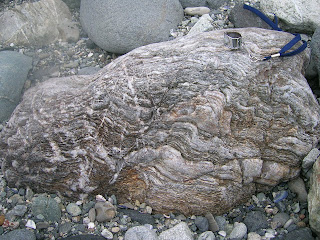
Seeing as all of the stuff in this breccia was spit out of a subduction zone, one would expect a bunch of spectacularly deformed metamorphic rocks. I thought this one was particularly awesome, since it has clearly been kicked back and forth between brittle and ductile zones several times. There are places where twisted and folded bands have been displaced across a clear break, but also places where a break with displacement across it has been twisted and folded in turn. It really is amazing how much can happen to one rock without its past history getting distorted beyond a point where it can be deciphered.
And that is it for this quarter's field trips. But I'm going on a week long fault-poking road trip next week (the Carrizo Plain is the longest stop on the itinerary), and I've been invited to go on some field trips for a class I'm not officially taking next quarter, so I am not doomed to spending too much time indoors!

The weather looked pretty threatening the entire time, but there fortunately was no actual rain.

This is a section of the breccia from Laguna Beach; the clay matrix is redder at Dana Point. Only reason I'm not posting one of those shots is I'm not sure whether or not my classmates would appreciate being in my blog, particularly if I'm only using them as scale.

The San Onofre formation is riddled with a bunch of little faults, like this one. We also saw two or three buildings - one of which is a popular restaurant - that are directly on top of some of said faults. They manifest pretty clearly, so one would think builders would shift stuff a few meters out of the way, but nope. Perhaps The O.C. is too cool for avoiding faults...

This fault had one of its sliding surfaces partly exposed, complete with weathered slickensides. Though my finger is ostensibly for scale, I also could not pass up the opportunity to take "fault poking" (my term for merely visiting faults) to a whole new level.

Some of these faults, as well as other cracks/fractures were healed up with calcite.

This is a narrow crevasse/groove that is developing a druse of calcite. (The dead bug is not for scale. The groove in question is about two inches wide and several feet long.) Apparently the mineralogy class goes on this trip every year, and this encrusting of crystals was not there last year.

Seeing as all of the stuff in this breccia was spit out of a subduction zone, one would expect a bunch of spectacularly deformed metamorphic rocks. I thought this one was particularly awesome, since it has clearly been kicked back and forth between brittle and ductile zones several times. There are places where twisted and folded bands have been displaced across a clear break, but also places where a break with displacement across it has been twisted and folded in turn. It really is amazing how much can happen to one rock without its past history getting distorted beyond a point where it can be deciphered.
And that is it for this quarter's field trips. But I'm going on a week long fault-poking road trip next week (the Carrizo Plain is the longest stop on the itinerary), and I've been invited to go on some field trips for a class I'm not officially taking next quarter, so I am not doomed to spending too much time indoors!
Tuesday, March 18, 2008
Not Easy Being Green
My internet connection was on the fritz all day yesterday, so I missed the best timing for posting a mysterious green deskcrop of my own. I'm still going to post it, though, since I'm not even entirely sure what it is. There was plenty of this stuff around at Dana Point Harbor, where my mineralogy class went for a field trip on 1 March. Even the professor wasn't sure what it was, so we collected some of it (and I very nearly spoiled the sample with blood after slicing my thumb on my knife trying to extract some of the green stuff) for analysis. I ran XRD on it, and one of my classmates put it under SEM...and we came up with completely unrelated results. My guess is the problem might have been in the preparation of the thin section for SEM, since this stuff has a hardness of less than two and powders so easily that I'm sure getting a clean even slice would be really difficult. We're going to put the powder we prepared for XRD into SEM after spring break, in hopes of clearing this up. But in the spirit of geopuzzles, I am consulting you guys, too! I'll let you know if your guess is what I came up with in XRD, or what my classmate came up with in SEM, though neither one is confirmed. I don't have any prizes to give, though I guess I could draw a silly picture for someone if they get it, or have a compelling argument for something other than what we tested.

There were a bunch of places where the mysterious soft green stuff appeared to form puddles in larger rocks.

In other places, the mysterious green mineral clearly followed the foliation of the rock; this was further supported when I was drilling out the green for the XRD sample - the drill bit went very deep into a tiny surface spot of material, but was still churning out green.
In terms of environment, Dana Point, in Orange County, is dominated by the San Onofre Breccia, which consists mainly of blueschists, with some greenschists and amphibolites, in a red clay matrix. Many of the rocks there show signs of being kicked back and forth between brittle and ductile parts of the subduction zone. I'll put a bunch more photos in the next post.

There were a bunch of places where the mysterious soft green stuff appeared to form puddles in larger rocks.

In other places, the mysterious green mineral clearly followed the foliation of the rock; this was further supported when I was drilling out the green for the XRD sample - the drill bit went very deep into a tiny surface spot of material, but was still churning out green.
In terms of environment, Dana Point, in Orange County, is dominated by the San Onofre Breccia, which consists mainly of blueschists, with some greenschists and amphibolites, in a red clay matrix. Many of the rocks there show signs of being kicked back and forth between brittle and ductile parts of the subduction zone. I'll put a bunch more photos in the next post.
Wednesday, March 5, 2008
Danger danger danger!
Less than three hours after I posted lamenting how I have more photos of my car tempting the geological fates than of myself doing the same, the TA of my mineralogy class sent me this photo from this past weekend's trip to the San Onofre breccia at Dana Point, Orange County. (Entire entry about that trip coming soon.)

I laugh in your face, oh cautionary sign! How dare you try to thwart my efforts to poke the little bitty fault!

I laugh in your face, oh cautionary sign! How dare you try to thwart my efforts to poke the little bitty fault!
Sunday, March 2, 2008
Pacific Silica Quarry
I have neither died nor fallen into the ocean, though it kind of feels like the latter, considering how I feel like I'm frantically doggy-paddling to keep afloat in all the reading, composition, thesis writing, rehearsals, performances, and occasional field trips.
The field trips, of course, are the fun part. My mineralogy class has gone on two in the past week, to vastly different but equally interesting places. I'll address these in two separate photo-heavy posts.
Last week's trip was to Pacific Silica Quarry in Perris, California. It has been long abandoned in terms of industrial purposes, but it's still open to anyone who wants to traverse very uneven, cracked, muddy, and hilly roads (the TA drove - the professor seemed pretty terrified) in search of minerals. The quarry taps into what seems to be a pretty big granitic pegmatite (far far bigger than the ones I mentioned in the Box Springs - those were only a couple of inches wide). It has all of the expected minerals for such a formation, with the added bonus of large schorl tourmaline crystals cutting across the quartz and feldspar.


 It also had some particularly interesting formations of biotite, in long narrow strips criscrossing the quartz and feldspar of the quarry walls in shapes that are reminiscent of Chinese calligraphy.
While there were a few assigned questions for the trip (mostly in the form of finding specific things and drawing them), a large portion of the time was allotted to simply looking around for interesting things. And, if I do say so myself, I think I did pretty well for finding interesting things. I found two big chunks of euhedral k-feldspar - neither is the entire crystal, but one has five very clear crystal faces, and the other has what appears to be an enormous carlsbad twin. I also found a piece of quartz with a bunch of angular impressions in it that were obviously caused by k-spar crystals growing up against the quartz. Nobody else found any feldspar samples comparable to these, so I felt pretty awesome about it. They are now sitting very proudly on my desk.

Here's the one with five clear faces. For some reason, though, it did not want to be photographed without blur.
 And here's the one with the big twin. I haven't seen that narrow crystal face on any of the feldspar we've looked at in the lab.

This is the dented quartz. This picture shows only the biggest imprint, but there are a bunch of smaller ones on the underside of the sample.
Our TA found some tiny garnets on a piece of feldspar, and when we looked closer, we found a bunch more stuck in or next to the tourmaline. Though garnet is not weird for pegmatites, it apparently has not been documented in this particular pegmatite before - there was no mention of it on the USGS map we had for the site, and the professor said she hadn't come across mention of them after years of reading up on the area in preparation for taking mineralogy classes there. She encouraged us to contact the USGS about what we found. (I think she's a fantastic teacher, and stuff like this is one of the reasons. She gets students excited to find things, and holds up that what we do find is significant beyond the scope of a grade in a class.)
A non-mineralogical thing that made me excited about this site was the view. Standing at the top of the hill into which the quarry was blasted, one is afforded an amazing view, from the San Gabriel Mountains down to Mt. San Jacinto. It's a much wider and less-polluted view than from the Box Springs. I loved being able to follow the such long sections of the paths of the San Andreas and San Jacinto Faults by tracing my finger in the air along prominent features (complete with scribbly circle thing upon hitting Mt. San Gorgonio).

We also had excellent weather timing. It was clear the entire time we were poking around in the quarry, but started to drizzle as soon as we got back in the vehicle. Half an hour earlier and we might have missed the garnets, but it held out just as long as we needed.
The field trips, of course, are the fun part. My mineralogy class has gone on two in the past week, to vastly different but equally interesting places. I'll address these in two separate photo-heavy posts.
Last week's trip was to Pacific Silica Quarry in Perris, California. It has been long abandoned in terms of industrial purposes, but it's still open to anyone who wants to traverse very uneven, cracked, muddy, and hilly roads (the TA drove - the professor seemed pretty terrified) in search of minerals. The quarry taps into what seems to be a pretty big granitic pegmatite (far far bigger than the ones I mentioned in the Box Springs - those were only a couple of inches wide). It has all of the expected minerals for such a formation, with the added bonus of large schorl tourmaline crystals cutting across the quartz and feldspar.


 It also had some particularly interesting formations of biotite, in long narrow strips criscrossing the quartz and feldspar of the quarry walls in shapes that are reminiscent of Chinese calligraphy.
While there were a few assigned questions for the trip (mostly in the form of finding specific things and drawing them), a large portion of the time was allotted to simply looking around for interesting things. And, if I do say so myself, I think I did pretty well for finding interesting things. I found two big chunks of euhedral k-feldspar - neither is the entire crystal, but one has five very clear crystal faces, and the other has what appears to be an enormous carlsbad twin. I also found a piece of quartz with a bunch of angular impressions in it that were obviously caused by k-spar crystals growing up against the quartz. Nobody else found any feldspar samples comparable to these, so I felt pretty awesome about it. They are now sitting very proudly on my desk.

Here's the one with five clear faces. For some reason, though, it did not want to be photographed without blur.
 And here's the one with the big twin. I haven't seen that narrow crystal face on any of the feldspar we've looked at in the lab.
This is the dented quartz. This picture shows only the biggest imprint, but there are a bunch of smaller ones on the underside of the sample.
Our TA found some tiny garnets on a piece of feldspar, and when we looked closer, we found a bunch more stuck in or next to the tourmaline. Though garnet is not weird for pegmatites, it apparently has not been documented in this particular pegmatite before - there was no mention of it on the USGS map we had for the site, and the professor said she hadn't come across mention of them after years of reading up on the area in preparation for taking mineralogy classes there. She encouraged us to contact the USGS about what we found. (I think she's a fantastic teacher, and stuff like this is one of the reasons. She gets students excited to find things, and holds up that what we do find is significant beyond the scope of a grade in a class.)
A non-mineralogical thing that made me excited about this site was the view. Standing at the top of the hill into which the quarry was blasted, one is afforded an amazing view, from the San Gabriel Mountains down to Mt. San Jacinto. It's a much wider and less-polluted view than from the Box Springs. I loved being able to follow the such long sections of the paths of the San Andreas and San Jacinto Faults by tracing my finger in the air along prominent features (complete with scribbly circle thing upon hitting Mt. San Gorgonio).

We also had excellent weather timing. It was clear the entire time we were poking around in the quarry, but started to drizzle as soon as we got back in the vehicle. Half an hour earlier and we might have missed the garnets, but it held out just as long as we needed.
Subscribe to:
Posts (Atom)