I really don't mean to be neglecting my blog (or neglecting commenting on your blogs) as much as I have been lately. It's mostly that, after the classes and the rehearsals and the homework and the grading, I put aside the papers and think only of sleep, rather than of spending more time at a screen writing things. I'm accumulating a rather lengthy To-Blog list, which, following Maria's lead> I think I'll have to make a summer break resolution (since New Year's is way too far off) to actually write up.
Anyway, though much of my time this quarter has been spent at a desk, the seminar I'm taking on tectonic geomorphology and quaternary field methods has served well to get me out and about. Many of our "trips" have been into the hills behind campus, mostly for funding reasons, but we have had a few larger outings. The most intensive one so far was when we went to Grass Valley in the San Bernardino Mountains to make a digital elevation map using kinematic GPS. (There was also a USGS/Caltech team out there using LiDAR to image some precariously balanced rocks, but we did not get to actively participate in this part of the work; we were mere observers.)
Grass Valley is located in the San Bernardino Mountains, not far from Lake Arrowhead. It falls into the region of highest possible threat of major earthquake ground motion in the state, due to its proximity to several major faults. The San Andreas Fault is 11 kilometers away, with several well-constrained paleoseismic sites within 20 km. The San Jacinto Fault is only a kilometer or two further away than the San Andreas; the north frontal thrust of the San Bernardino Mountains is about the same distance away to the north. The Cleghorn Fault runs directly through Grass Valley, though its activity isn't as well constrained; there's no current microseismicity, and no evidence of Holocene rupture.
The precariously balanced rock team was clearly there to try and constrain whether or not the worst case scenario of shaking according to the state hazard report had actually ever happened since those rocks became precarious to begin with. The focus of the class exercise, however, was more on a catchment containing a small system of drainages in the process of being captured by the Mojave River. Our goal was to use kinematic GPS to get a good picture of the area, which could then be used to better situate the precariously balanced rocks in the middle of the site.
Kinematic GPS is a method of relative measurement. Actual latitude/longitude figures don't come into play. All measurements are taken relative to a base station that gets set up somewhere central in the site, for the express purpose of kinematic GPS measurement. People then carry portable GPS antennae, either attached to a backpack or on a long pole, all over the area surrounding the base station. The goal is to go back and forth over all of the bumps and dips in topography - even though that does, of course, make for harder hiking at times - to make sure they show up in the DEM. The data has to be corrected for height of the person carrying the antenna (I was not, shockingly, the shortest one!) and for roughness of gait, but the corrections that need to be made can be gauged by having all of the antenna-carryers walk the same path before going their separate ways.
We spent a full afternoon tromping around the catchment, and the four of us managed to cross paths only a couple of times, hopefully implying that we didn't all cover the same ground. In my run-in with one of the professors, I was detailed to walk around the far edge of the site that hadn't yet been covered. I did so, but then I proceeded to overshoot the other edge of the site and get quite confused. I continued to walk through all of the (mostly-dry) drainages I could find for a while, but I started to get worried when I wasn't catching sight of the base station or the precariously balanced rocks. I definitely realized the irony of not having a clue where I was, despite having a GPS antenna strapped to my back, but dark humor wasn't going to get me out of the situation on its own. I did manage to work my way back to the road, then proceeded to go the wrong way on it for about half a mile before I noticed that I was wrong. It turns out I'd found the road only about 200 yards shy of the turnoff that lead straight to the base station. Ah well!
I haven't seen our DEM yet, though I'm told we covered a lot of ground, and I'm told that there was one antenna that went quite a bit further away than all the others did. One of the people in the class is doing all the processing as his final project for said class, so I may ask him if I can show off the results of our day in the field.
Showing posts with label local geology. Show all posts
Showing posts with label local geology. Show all posts
Sunday, May 17, 2009

Sunday, November 30, 2008
Hiking Lake Elsinore
Yesterday, as a means of combating the sloth and gluttony inherent in Thanksgiving weekend, some friends and I went on a nine mile hike in the Santa Ana Mountains, above Lake Elsinore. It was a trip intended just for walking and being outside, rather than a specifically geological venture, but I was still pretty psyched about getting to hike around in a fault zone with which I didn't have much up close experience. To my disappointment, the trail we selected was far enough up into the mountains that the fault trace itself wasn't actually visible, and all of the outcrops we encountered were between granite and granodiorite, with rounded weathering, and undeformed/unmetamorphosed. (I was not the only one slightly bummed - the only bugs we saw were termites, which was a disappointment to the entomologist on the hike, and the two plant biologists were not thrilled that most of the vegetation was invasive.) That said, it was still a wonderful hike. The weather was great, the scenery was gorgeous despite its lack of faults, and it just plain felt good to get out and walk without the purpose of going somewhere. I wish I could afford the time to go and do this more often in the middle of the quarter. Backlogged homework would kill me dead if I tried, though.
On the drive down from the trailhead, there were some fantastic views:
You can see three of southern California's most prominent peaks from here: from left to right, Mt. Baldy (highest in the San Gabriels), Mt. San Gorgonio (highest in the San Bernardinos), and Mt. San Jacinto (highest in the San Jacintos). You also get a great look at three major fault zones: the San Andreas runs at the foot of the San Bernardinos, from just to the right of Mt. Baldy off to the end of the page; the San Jacinto runs in front of its like-named mountain, branching off the San Andreas to the right of Mt. Baldy and continuing in the other direction toward the end of the image; the Elsinore is in the foreground, with one strand on either side of the lake. Lake Elsinore is, in fact, there to begin with because of this extensional stepover in the fault (and I miiight even look at the possible dynamics of that particular stepover in my thesis, maybe).
This panorama also illustrates a particularly heinous case of Houses On Faults. The houses directly on the banks of Lake Elsinore are smack dab on the fault trace, but the neighborhoods that sit between the base of the Santa Ana mountains and the lower string of hills directly opposite the lake are sandwiched in that extensional zone. That does not bode well for ground motion in and of itself, but it becomes an even sticker situation when you consider the soft lake sediment around there. I also wouldn't be surprised if the liquefaction hazard there is much higher than in pretty much the rest of the Inland Empire (though I'd have to look it up - I haven't done that yet). The houses we drove past also look pretty new, likely newer than the Alquist-Priolo act. I guess most of them fall within the fifty-feet-away clause, but really, what's fifty feet compared to the speed of P-waves? The Elsinore may not have one of the higher seismic hazards in California according to this spring's figures, and it may not be as well known of a fault, but it definitely does still move (last September's 4.7 was on the Elsinore), and I definitely wouldn't want to live on it.
I would, however, be more than glad to hike there again.
On the drive down from the trailhead, there were some fantastic views:

You can see three of southern California's most prominent peaks from here: from left to right, Mt. Baldy (highest in the San Gabriels), Mt. San Gorgonio (highest in the San Bernardinos), and Mt. San Jacinto (highest in the San Jacintos). You also get a great look at three major fault zones: the San Andreas runs at the foot of the San Bernardinos, from just to the right of Mt. Baldy off to the end of the page; the San Jacinto runs in front of its like-named mountain, branching off the San Andreas to the right of Mt. Baldy and continuing in the other direction toward the end of the image; the Elsinore is in the foreground, with one strand on either side of the lake. Lake Elsinore is, in fact, there to begin with because of this extensional stepover in the fault (and I miiight even look at the possible dynamics of that particular stepover in my thesis, maybe).
This panorama also illustrates a particularly heinous case of Houses On Faults. The houses directly on the banks of Lake Elsinore are smack dab on the fault trace, but the neighborhoods that sit between the base of the Santa Ana mountains and the lower string of hills directly opposite the lake are sandwiched in that extensional zone. That does not bode well for ground motion in and of itself, but it becomes an even sticker situation when you consider the soft lake sediment around there. I also wouldn't be surprised if the liquefaction hazard there is much higher than in pretty much the rest of the Inland Empire (though I'd have to look it up - I haven't done that yet). The houses we drove past also look pretty new, likely newer than the Alquist-Priolo act. I guess most of them fall within the fifty-feet-away clause, but really, what's fifty feet compared to the speed of P-waves? The Elsinore may not have one of the higher seismic hazards in California according to this spring's figures, and it may not be as well known of a fault, but it definitely does still move (last September's 4.7 was on the Elsinore), and I definitely wouldn't want to live on it.
I would, however, be more than glad to hike there again.
Monday, August 18, 2008
Pull-apart basins of the Inland Empire
Last Wednesday, despite the ludicrous August-in-SoCal temperatures, those of us who are hanging around the UCR geology building this summer had the opportunity to go on a field trip to look at pull-apart basins on the San Andreas and San Jacinto Faults. The trip was led by one of the senior faculty members here, who worked at USGS for a long time (and whose name is on quite a few USGS maps of the area) before coming to teach here; I'd heard he leads some awesome field trips, so how could I pass this up, weather aside? Long story short, there was no disappointment whatsoever, and I learned almost more than I thought possible for a four-hour air-conditioned car ride.
This trip managed to tell three different stories. The first was structural; the pull-apart basins we visited on this trip come from extensional stepovers within single faults, in this case right-lateral strike slip faults that step to the right of each other. As the faults pull, the land between them subsides, creating a basin that's ripe for flooding. Sediment accumulates in these basins, and the rapid subsidence also causes the sides mountains surrounding the basin to slough off in landslides. Most of the mountains we saw showed rolled landslide toes, rather than clean faceted ridges. The San Jacinto/Hemet basin is still actively sinking, and at this time of year, that sediment shows itself as lots and lots of dust. I've been past this area before, and at the time, I laughed at the thought that a completely dry area was marked as a river overflow zone, but this field trip told me why! The subsidence is uneven enough that the San Jacinto River, when it has water in it, runs right up against the base of the mountains. That barrier makes pooling up all the easier, and it doesn't take much water to start spilling over toward neighborhoods and farms. We followed this up by visiting the inactive Mill Creek basin on the San Andreas, near Yucaipa and Crafton Hills. Here again is a body of water (with actual water in it this time!) right up against the mountains. Natural exposures and roadcuts alike show thick layers of sandstone, some with ample evidence of soft-sediment deformation (likely coseismic), between the basement rock on either side of the basin. The extension that formed this basin is also responsible for a series of normal faults in Crafton Hills; the San Jacinto basin will likely develop these as well, given enough time.
The second story here is about mapping. The area around both of these extensional basins has been mapped many times, by several different agencies, and there has been a tendency to ignore features specifically related to extension and assume that the faults are more literally responsible for every geomorphic feature in the area. Subsidence scarps have, in the past, been marked as fault scarps. The sharp boundaries between basement and accumulated sediment - ie, the edges of the basin - are also often taken as faults. The latter isn't just a pull-apart basin problem: the Perris Block, on which Riverside sits, has not deformed much internally in recent geologic time, but it had plenty of internal topography, and the lower points have accumulated sediment as the entire block moves up and down. The boundaries between this sediment and any mountains sticking out of it have been marked as faults, but tracing them reveals that they're essentially round! (Older maps actually put a fault at the end of my street, thanks to this misinterpretation. Boy am I glad this is wrong!) Assumptions that faults sit in front of the mountains also don't quite work for pull-apart basins, since landslides roll off the mountains and cover the trace. There have been several incidents of people trenching the "fault" at the base of the mountain, coming up with nothing, and being happy with that answer. Sometimes, a landslide will re-expose a fault scarp, as with above Soboba Springs, and that scarp seems to slice the mountain almost through its middle. Smaller landslides also obscure several much larger ones that bound the basin; the small ones get mapped and the large ones don't, a "forest for the trees" scenario, to use our guide's term. Fortunately, now that the structure and function of pull-apart basins is better understood, maps can be corrected and updated to better represent the region and its underlying processes.
The final story is one of people building things in really stupid places. The active San Jacinto basin is full of houses, many quite new. They're slightly higher up than the San Jacinto river, but slightly isn't going to help, when the whole area is so much lower than everything around it. And it's not that this is a slow process, either! There are stories of houses that were built 50 years ago, carefully planned so that the high water mark was several feet below where the house stood. Recent floods have dumped four feet of water into those houses. Add in the landslides off the mountains and the being wedged between two strands of one of the most active faults in California, and you've got a big problem. We passed a bunch of houses on fault scarps on the course of this trip, though many of these houses looked older and fairly isolated, likely the personal decision of a landowner rather than a clueless developer. Crafton Hills, however, is a different story. Fault scarps serrate this landscape, and those scarps are liberally dotted with brand new development of large and presumably spiffy houses. There is no way these developments could fit in with Alquist-Priolo regulations, but there they are. Were those normal faults not evaluated as hazardous compared to nearby strike-slip faults? Did nobody bother to trench to begin with? Did the developers blatantly ignore the rules and warnings? I have no idea, but I know I wouldn't want to live there.
This trip managed to tell three different stories. The first was structural; the pull-apart basins we visited on this trip come from extensional stepovers within single faults, in this case right-lateral strike slip faults that step to the right of each other. As the faults pull, the land between them subsides, creating a basin that's ripe for flooding. Sediment accumulates in these basins, and the rapid subsidence also causes the sides mountains surrounding the basin to slough off in landslides. Most of the mountains we saw showed rolled landslide toes, rather than clean faceted ridges. The San Jacinto/Hemet basin is still actively sinking, and at this time of year, that sediment shows itself as lots and lots of dust. I've been past this area before, and at the time, I laughed at the thought that a completely dry area was marked as a river overflow zone, but this field trip told me why! The subsidence is uneven enough that the San Jacinto River, when it has water in it, runs right up against the base of the mountains. That barrier makes pooling up all the easier, and it doesn't take much water to start spilling over toward neighborhoods and farms. We followed this up by visiting the inactive Mill Creek basin on the San Andreas, near Yucaipa and Crafton Hills. Here again is a body of water (with actual water in it this time!) right up against the mountains. Natural exposures and roadcuts alike show thick layers of sandstone, some with ample evidence of soft-sediment deformation (likely coseismic), between the basement rock on either side of the basin. The extension that formed this basin is also responsible for a series of normal faults in Crafton Hills; the San Jacinto basin will likely develop these as well, given enough time.
The second story here is about mapping. The area around both of these extensional basins has been mapped many times, by several different agencies, and there has been a tendency to ignore features specifically related to extension and assume that the faults are more literally responsible for every geomorphic feature in the area. Subsidence scarps have, in the past, been marked as fault scarps. The sharp boundaries between basement and accumulated sediment - ie, the edges of the basin - are also often taken as faults. The latter isn't just a pull-apart basin problem: the Perris Block, on which Riverside sits, has not deformed much internally in recent geologic time, but it had plenty of internal topography, and the lower points have accumulated sediment as the entire block moves up and down. The boundaries between this sediment and any mountains sticking out of it have been marked as faults, but tracing them reveals that they're essentially round! (Older maps actually put a fault at the end of my street, thanks to this misinterpretation. Boy am I glad this is wrong!) Assumptions that faults sit in front of the mountains also don't quite work for pull-apart basins, since landslides roll off the mountains and cover the trace. There have been several incidents of people trenching the "fault" at the base of the mountain, coming up with nothing, and being happy with that answer. Sometimes, a landslide will re-expose a fault scarp, as with above Soboba Springs, and that scarp seems to slice the mountain almost through its middle. Smaller landslides also obscure several much larger ones that bound the basin; the small ones get mapped and the large ones don't, a "forest for the trees" scenario, to use our guide's term. Fortunately, now that the structure and function of pull-apart basins is better understood, maps can be corrected and updated to better represent the region and its underlying processes.
The final story is one of people building things in really stupid places. The active San Jacinto basin is full of houses, many quite new. They're slightly higher up than the San Jacinto river, but slightly isn't going to help, when the whole area is so much lower than everything around it. And it's not that this is a slow process, either! There are stories of houses that were built 50 years ago, carefully planned so that the high water mark was several feet below where the house stood. Recent floods have dumped four feet of water into those houses. Add in the landslides off the mountains and the being wedged between two strands of one of the most active faults in California, and you've got a big problem. We passed a bunch of houses on fault scarps on the course of this trip, though many of these houses looked older and fairly isolated, likely the personal decision of a landowner rather than a clueless developer. Crafton Hills, however, is a different story. Fault scarps serrate this landscape, and those scarps are liberally dotted with brand new development of large and presumably spiffy houses. There is no way these developments could fit in with Alquist-Priolo regulations, but there they are. Were those normal faults not evaluated as hazardous compared to nearby strike-slip faults? Did nobody bother to trench to begin with? Did the developers blatantly ignore the rules and warnings? I have no idea, but I know I wouldn't want to live there.
Saturday, July 26, 2008
Where ATVs and Bruntons Meet
I haven't been to field camp, and I likely won't get to due to all of the academic catchup that comes with a major switch of fields this late in the game. I did get to take a field mapping course this past quarter, though, and I enjoyed almost every minute of it (I say almost, because the one day where it got up to 105 in the shade, and there wasn't any shade, was a bit intense). The professor outright asked me to take his class, never mind that I didn't have the prerequisite. The class involved ten days in the field, split between two different field areas in the Mojave Desert. Some of those trips were only for a single day - both areas were a nice hour and a half drive away from campus - but there were three full-weekend outings involved, which meant I still got some of the campfire conversation aspect of longer-term field camp.
Of the two field areas, I was particularly taken with the sedimentary-focused one. Mule Canyon is in the Calico Mountains, off the same freeway exit that takes you to Calico Ghost Town. The canyon exposes the bright greens, reds, yellows, and oranges of the Miocene Barstow Formation (though without the fossils, from what I understand), plus some younger caps of purple(!) extrusive volcanics. The name "Calico Mountains" explained itself right there. Mule Canyon ranks up among the most beautiful places I've ever visited, and I really enjoyed mapping it. To me, it was like a giant puzzle, only I had to walk on the pieces to match edges, rather than snapping everything together from one bird's eye view.

The colors of Mule Canyon. I really wish I'd taken a long panoramic shot of the whole place.
We were the only geology class out there for the six days we spent in Mule Canyon, but there was no shortage of other people. Mule Canyon is a popular spot for RVers, offroaders, and shooting enthusiasts. Mapping there was never quiet: there was constant engine noise, spatters of gunfire all too close to the actual mapped area, and one RV that seemed to be in the same spot playing the same Britney Spears CD on repeat for several of our visits. It was also never without its share of idiocy, mostly not on the part of our class: the first day we were there, some visitor had the brilliant idea to shoot across the road, and there were all kinds of incidents of people attempting to drive vehicles up hills that were entirely too steep and sandy to really be wise. (We had fun with this one. One night, well after dark, we saw ATV lights running across what was clearly our measured section - a high and narrow measured section, no less - so the professor led a charge toward them with flashlights. They proceeded to leave.)
But the Britney Spears, the ricochets, and the jeeps cutting back and forth across beds I was trying to map did not even come close to making the experience of mapping at Mule Canyon a bad one. It's too fantastic and fascinating of a place for that. (We only mapped the predominantly-homoclinal section of it. There are crazy folds all around that are absolutely worth going back for.) If anything, I pity the recreational users of that land, too busy putting bulletholes and tire tracks into the landscape to realize its beauty.
Of the two field areas, I was particularly taken with the sedimentary-focused one. Mule Canyon is in the Calico Mountains, off the same freeway exit that takes you to Calico Ghost Town. The canyon exposes the bright greens, reds, yellows, and oranges of the Miocene Barstow Formation (though without the fossils, from what I understand), plus some younger caps of purple(!) extrusive volcanics. The name "Calico Mountains" explained itself right there. Mule Canyon ranks up among the most beautiful places I've ever visited, and I really enjoyed mapping it. To me, it was like a giant puzzle, only I had to walk on the pieces to match edges, rather than snapping everything together from one bird's eye view.

The colors of Mule Canyon. I really wish I'd taken a long panoramic shot of the whole place.
We were the only geology class out there for the six days we spent in Mule Canyon, but there was no shortage of other people. Mule Canyon is a popular spot for RVers, offroaders, and shooting enthusiasts. Mapping there was never quiet: there was constant engine noise, spatters of gunfire all too close to the actual mapped area, and one RV that seemed to be in the same spot playing the same Britney Spears CD on repeat for several of our visits. It was also never without its share of idiocy, mostly not on the part of our class: the first day we were there, some visitor had the brilliant idea to shoot across the road, and there were all kinds of incidents of people attempting to drive vehicles up hills that were entirely too steep and sandy to really be wise. (We had fun with this one. One night, well after dark, we saw ATV lights running across what was clearly our measured section - a high and narrow measured section, no less - so the professor led a charge toward them with flashlights. They proceeded to leave.)
But the Britney Spears, the ricochets, and the jeeps cutting back and forth across beds I was trying to map did not even come close to making the experience of mapping at Mule Canyon a bad one. It's too fantastic and fascinating of a place for that. (We only mapped the predominantly-homoclinal section of it. There are crazy folds all around that are absolutely worth going back for.) If anything, I pity the recreational users of that land, too busy putting bulletholes and tire tracks into the landscape to realize its beauty.
Saturday, March 22, 2008
San Onofre Breccia
I've pretty much managed to describe the entire field trip over the course of a few other entries by now, but I've been saying I'd post pictures for three weeks now, and I'm only delivering now. Eesh!

The weather looked pretty threatening the entire time, but there fortunately was no actual rain.

This is a section of the breccia from Laguna Beach; the clay matrix is redder at Dana Point. Only reason I'm not posting one of those shots is I'm not sure whether or not my classmates would appreciate being in my blog, particularly if I'm only using them as scale.

The San Onofre formation is riddled with a bunch of little faults, like this one. We also saw two or three buildings - one of which is a popular restaurant - that are directly on top of some of said faults. They manifest pretty clearly, so one would think builders would shift stuff a few meters out of the way, but nope. Perhaps The O.C. is too cool for avoiding faults...

This fault had one of its sliding surfaces partly exposed, complete with weathered slickensides. Though my finger is ostensibly for scale, I also could not pass up the opportunity to take "fault poking" (my term for merely visiting faults) to a whole new level.

Some of these faults, as well as other cracks/fractures were healed up with calcite.

This is a narrow crevasse/groove that is developing a druse of calcite. (The dead bug is not for scale. The groove in question is about two inches wide and several feet long.) Apparently the mineralogy class goes on this trip every year, and this encrusting of crystals was not there last year.
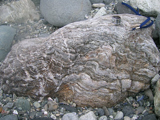
Seeing as all of the stuff in this breccia was spit out of a subduction zone, one would expect a bunch of spectacularly deformed metamorphic rocks. I thought this one was particularly awesome, since it has clearly been kicked back and forth between brittle and ductile zones several times. There are places where twisted and folded bands have been displaced across a clear break, but also places where a break with displacement across it has been twisted and folded in turn. It really is amazing how much can happen to one rock without its past history getting distorted beyond a point where it can be deciphered.
And that is it for this quarter's field trips. But I'm going on a week long fault-poking road trip next week (the Carrizo Plain is the longest stop on the itinerary), and I've been invited to go on some field trips for a class I'm not officially taking next quarter, so I am not doomed to spending too much time indoors!

The weather looked pretty threatening the entire time, but there fortunately was no actual rain.

This is a section of the breccia from Laguna Beach; the clay matrix is redder at Dana Point. Only reason I'm not posting one of those shots is I'm not sure whether or not my classmates would appreciate being in my blog, particularly if I'm only using them as scale.

The San Onofre formation is riddled with a bunch of little faults, like this one. We also saw two or three buildings - one of which is a popular restaurant - that are directly on top of some of said faults. They manifest pretty clearly, so one would think builders would shift stuff a few meters out of the way, but nope. Perhaps The O.C. is too cool for avoiding faults...

This fault had one of its sliding surfaces partly exposed, complete with weathered slickensides. Though my finger is ostensibly for scale, I also could not pass up the opportunity to take "fault poking" (my term for merely visiting faults) to a whole new level.

Some of these faults, as well as other cracks/fractures were healed up with calcite.

This is a narrow crevasse/groove that is developing a druse of calcite. (The dead bug is not for scale. The groove in question is about two inches wide and several feet long.) Apparently the mineralogy class goes on this trip every year, and this encrusting of crystals was not there last year.

Seeing as all of the stuff in this breccia was spit out of a subduction zone, one would expect a bunch of spectacularly deformed metamorphic rocks. I thought this one was particularly awesome, since it has clearly been kicked back and forth between brittle and ductile zones several times. There are places where twisted and folded bands have been displaced across a clear break, but also places where a break with displacement across it has been twisted and folded in turn. It really is amazing how much can happen to one rock without its past history getting distorted beyond a point where it can be deciphered.
And that is it for this quarter's field trips. But I'm going on a week long fault-poking road trip next week (the Carrizo Plain is the longest stop on the itinerary), and I've been invited to go on some field trips for a class I'm not officially taking next quarter, so I am not doomed to spending too much time indoors!
Sunday, March 2, 2008
Pacific Silica Quarry
I have neither died nor fallen into the ocean, though it kind of feels like the latter, considering how I feel like I'm frantically doggy-paddling to keep afloat in all the reading, composition, thesis writing, rehearsals, performances, and occasional field trips.
The field trips, of course, are the fun part. My mineralogy class has gone on two in the past week, to vastly different but equally interesting places. I'll address these in two separate photo-heavy posts.
Last week's trip was to Pacific Silica Quarry in Perris, California. It has been long abandoned in terms of industrial purposes, but it's still open to anyone who wants to traverse very uneven, cracked, muddy, and hilly roads (the TA drove - the professor seemed pretty terrified) in search of minerals. The quarry taps into what seems to be a pretty big granitic pegmatite (far far bigger than the ones I mentioned in the Box Springs - those were only a couple of inches wide). It has all of the expected minerals for such a formation, with the added bonus of large schorl tourmaline crystals cutting across the quartz and feldspar.


 It also had some particularly interesting formations of biotite, in long narrow strips criscrossing the quartz and feldspar of the quarry walls in shapes that are reminiscent of Chinese calligraphy.
While there were a few assigned questions for the trip (mostly in the form of finding specific things and drawing them), a large portion of the time was allotted to simply looking around for interesting things. And, if I do say so myself, I think I did pretty well for finding interesting things. I found two big chunks of euhedral k-feldspar - neither is the entire crystal, but one has five very clear crystal faces, and the other has what appears to be an enormous carlsbad twin. I also found a piece of quartz with a bunch of angular impressions in it that were obviously caused by k-spar crystals growing up against the quartz. Nobody else found any feldspar samples comparable to these, so I felt pretty awesome about it. They are now sitting very proudly on my desk.

Here's the one with five clear faces. For some reason, though, it did not want to be photographed without blur.
 And here's the one with the big twin. I haven't seen that narrow crystal face on any of the feldspar we've looked at in the lab.

This is the dented quartz. This picture shows only the biggest imprint, but there are a bunch of smaller ones on the underside of the sample.
Our TA found some tiny garnets on a piece of feldspar, and when we looked closer, we found a bunch more stuck in or next to the tourmaline. Though garnet is not weird for pegmatites, it apparently has not been documented in this particular pegmatite before - there was no mention of it on the USGS map we had for the site, and the professor said she hadn't come across mention of them after years of reading up on the area in preparation for taking mineralogy classes there. She encouraged us to contact the USGS about what we found. (I think she's a fantastic teacher, and stuff like this is one of the reasons. She gets students excited to find things, and holds up that what we do find is significant beyond the scope of a grade in a class.)
A non-mineralogical thing that made me excited about this site was the view. Standing at the top of the hill into which the quarry was blasted, one is afforded an amazing view, from the San Gabriel Mountains down to Mt. San Jacinto. It's a much wider and less-polluted view than from the Box Springs. I loved being able to follow the such long sections of the paths of the San Andreas and San Jacinto Faults by tracing my finger in the air along prominent features (complete with scribbly circle thing upon hitting Mt. San Gorgonio).

We also had excellent weather timing. It was clear the entire time we were poking around in the quarry, but started to drizzle as soon as we got back in the vehicle. Half an hour earlier and we might have missed the garnets, but it held out just as long as we needed.
The field trips, of course, are the fun part. My mineralogy class has gone on two in the past week, to vastly different but equally interesting places. I'll address these in two separate photo-heavy posts.
Last week's trip was to Pacific Silica Quarry in Perris, California. It has been long abandoned in terms of industrial purposes, but it's still open to anyone who wants to traverse very uneven, cracked, muddy, and hilly roads (the TA drove - the professor seemed pretty terrified) in search of minerals. The quarry taps into what seems to be a pretty big granitic pegmatite (far far bigger than the ones I mentioned in the Box Springs - those were only a couple of inches wide). It has all of the expected minerals for such a formation, with the added bonus of large schorl tourmaline crystals cutting across the quartz and feldspar.


 It also had some particularly interesting formations of biotite, in long narrow strips criscrossing the quartz and feldspar of the quarry walls in shapes that are reminiscent of Chinese calligraphy.
While there were a few assigned questions for the trip (mostly in the form of finding specific things and drawing them), a large portion of the time was allotted to simply looking around for interesting things. And, if I do say so myself, I think I did pretty well for finding interesting things. I found two big chunks of euhedral k-feldspar - neither is the entire crystal, but one has five very clear crystal faces, and the other has what appears to be an enormous carlsbad twin. I also found a piece of quartz with a bunch of angular impressions in it that were obviously caused by k-spar crystals growing up against the quartz. Nobody else found any feldspar samples comparable to these, so I felt pretty awesome about it. They are now sitting very proudly on my desk.

Here's the one with five clear faces. For some reason, though, it did not want to be photographed without blur.
 And here's the one with the big twin. I haven't seen that narrow crystal face on any of the feldspar we've looked at in the lab.
This is the dented quartz. This picture shows only the biggest imprint, but there are a bunch of smaller ones on the underside of the sample.
Our TA found some tiny garnets on a piece of feldspar, and when we looked closer, we found a bunch more stuck in or next to the tourmaline. Though garnet is not weird for pegmatites, it apparently has not been documented in this particular pegmatite before - there was no mention of it on the USGS map we had for the site, and the professor said she hadn't come across mention of them after years of reading up on the area in preparation for taking mineralogy classes there. She encouraged us to contact the USGS about what we found. (I think she's a fantastic teacher, and stuff like this is one of the reasons. She gets students excited to find things, and holds up that what we do find is significant beyond the scope of a grade in a class.)
A non-mineralogical thing that made me excited about this site was the view. Standing at the top of the hill into which the quarry was blasted, one is afforded an amazing view, from the San Gabriel Mountains down to Mt. San Jacinto. It's a much wider and less-polluted view than from the Box Springs. I loved being able to follow the such long sections of the paths of the San Andreas and San Jacinto Faults by tracing my finger in the air along prominent features (complete with scribbly circle thing upon hitting Mt. San Gorgonio).

We also had excellent weather timing. It was clear the entire time we were poking around in the quarry, but started to drizzle as soon as we got back in the vehicle. Half an hour earlier and we might have missed the garnets, but it held out just as long as we needed.
Sunday, January 20, 2008
Box Springs Mountains
The Box Springs is not a large mountain range, but its location, not its size, makes it a fairly prominent feature in inland southern California. It juts up in the middle of the Inland Empire, separating Riverside from Moreno Valley from Loma Linda and Redlands, about halfway between the San Bernardino Mountains, separating suburbia from the desert, to the Santa Ana Mountains, beyond which lies the alternate dimension that is Orange County. It is not a particularly unusual range compositionally, consisting mostly of granite and granodiorite, with some diorite, that was uplifted by faulting. It is a good place to introduce people to igneous rocks in the field (all of the Geo1 classes here go into the Box Springs for one lab), and it has some nice examples of granitic pegmatites and of weathering by lots of wind and not much rain.
The Box Springs also happens to be the backdrop to our campus, marked with a huge concrete yellow C that's a common destination for hikers when the weather is temperate. Considering that the street on which I live goes right up to the base of the mountain, there's really no excuse for why I've only gone up a couple of times. A couple of my friends from the Javanese gamelan ensemble in which I play felt like going hiking today, so we headed up there - only my third time ever.
Today's hike pointed out what I personally think might be the most geologically interesting thing about the Box Springs - the view. Because the range is fairly central, on even a moderately smoggy day (but not a day on which the whole region is on fire), one can see many of the large scale features of the area. The San Jacinto Fault runs through the Box Springs, so looking down the length of the range (and following that same line to the northwest, past the last peak) shows the location of that fault. Looking north from the big concrete C, there's a fantastic view of Mt. Baldy, the highest point in the San Gabriel Mountains. At the base of those mountains, one can see a little bit of alluvial fan patterning before suburbia encroaches on the slope. Looking in this direction, the notch of the Cajon Pass, where the San Andreas Fault pulls the darker San Gabriels past the fainter San Bernardinos, is also clearly visible. From here, looking to the west shows the line of the Santa Ana mountains, with the Elsinore Fault tracing along their base. On the loop of the trail we took that went between two of the peaks, we got an excellent look at the San Bernardinos and their San Andreas straight base from the Cajon Pass to where one of the Box Springs peaks blocked the view. There were some other trails heading down around that peak that we didn't take, but I'd like to go down that way some time, since I can at least hope that the whole straight section until the fault hits the San Gorgonio knot could be seen from up there.
(I'd post photos, except none of them came out terribly well due to distance and encroaching smog. Bah!)
I tried to refrain from going on and on about how awesome I found it to be able to see all these major features in panorama from the middle, since I figured not all ethnomusicologists or composers would find this as exciting as I do. But as soon as one of my friends' attention was pulled in by the shininess of k-spar in a pegmatite, and as soon as she asked me what it was, all bets were off, and I kept pointing things out. The comment that, "I had no idea this stuff could be so interesting," was all the reason to keep talking.
The Box Springs also happens to be the backdrop to our campus, marked with a huge concrete yellow C that's a common destination for hikers when the weather is temperate. Considering that the street on which I live goes right up to the base of the mountain, there's really no excuse for why I've only gone up a couple of times. A couple of my friends from the Javanese gamelan ensemble in which I play felt like going hiking today, so we headed up there - only my third time ever.
Today's hike pointed out what I personally think might be the most geologically interesting thing about the Box Springs - the view. Because the range is fairly central, on even a moderately smoggy day (but not a day on which the whole region is on fire), one can see many of the large scale features of the area. The San Jacinto Fault runs through the Box Springs, so looking down the length of the range (and following that same line to the northwest, past the last peak) shows the location of that fault. Looking north from the big concrete C, there's a fantastic view of Mt. Baldy, the highest point in the San Gabriel Mountains. At the base of those mountains, one can see a little bit of alluvial fan patterning before suburbia encroaches on the slope. Looking in this direction, the notch of the Cajon Pass, where the San Andreas Fault pulls the darker San Gabriels past the fainter San Bernardinos, is also clearly visible. From here, looking to the west shows the line of the Santa Ana mountains, with the Elsinore Fault tracing along their base. On the loop of the trail we took that went between two of the peaks, we got an excellent look at the San Bernardinos and their San Andreas straight base from the Cajon Pass to where one of the Box Springs peaks blocked the view. There were some other trails heading down around that peak that we didn't take, but I'd like to go down that way some time, since I can at least hope that the whole straight section until the fault hits the San Gorgonio knot could be seen from up there.
(I'd post photos, except none of them came out terribly well due to distance and encroaching smog. Bah!)
I tried to refrain from going on and on about how awesome I found it to be able to see all these major features in panorama from the middle, since I figured not all ethnomusicologists or composers would find this as exciting as I do. But as soon as one of my friends' attention was pulled in by the shininess of k-spar in a pegmatite, and as soon as she asked me what it was, all bets were off, and I kept pointing things out. The comment that, "I had no idea this stuff could be so interesting," was all the reason to keep talking.
Subscribe to:
Posts (Atom)